
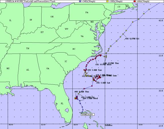
September 6-18, 2005
South Carolina Department of Natural Resources
Land, Water andConservation Division
South Carolina State Climatology Office
Compiled by Mark Malsick
Hurricane Ophelia, the fifteenth named tropical cyclone of the record setting 2005 hurricane season, began as a weak disturbance (Fig. 1) at the end of a decaying frontal system over the northwestern Bahamas. The National Hurricane Center (NHC) issued the first forecast for Tropical Depression 16 at 11 AM EDT on Tuesday, September 6, with the storm loosely centered at 26.5N, 078.6W. TD 16L slowly drifted north-northwest under the influence of weak mid-level steering currents. A NOAA aircraft reconnaissance found a well-defined, broad circulation center and a 1008 millibar central pressure. Later, another NOAA aircraft measured 27 knot flight level winds. Twenty-seven knot winds were also measured by NOAA buoy 41010 suggesting a slow intensification of TD 16. Initial forecasts were for TD 16L to become a tropical storm within 48-72 hours.
The National Hurricane Center upgraded TD 16L to Tropical Storm Ophelia (Fig. 2) early on Wednesday September 7, based on 33 knot buoy observations and Melbourne NWS Doppler radar velocities of 36-44 knots measured between 10,000 and 12,000 feet. Ophelia continued to become better organized and strengthened to 45 knots on September 7 as it slowly drifted northwest over warm ocean waters. Initial model guidance was inconclusive with great model disagreement (Fig. 3).
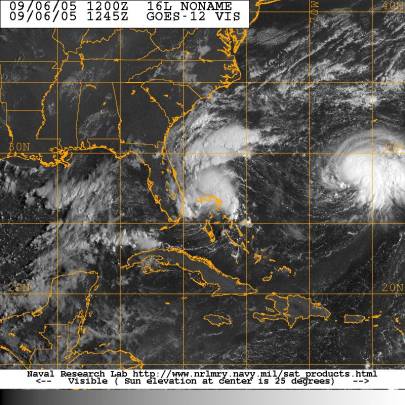
Figure 1. Tropical Depression 16L north of the Bahamas. TD16L later strengthened to become Hurricane Ophelia.
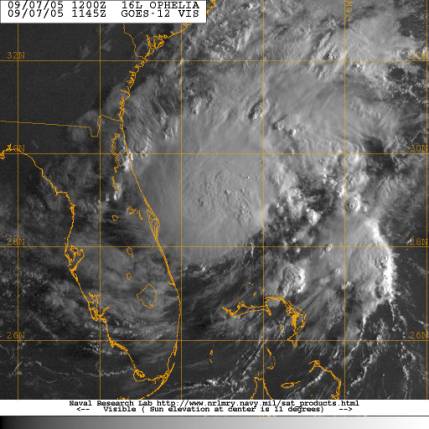
Figure 2. Tropical Storm Ophelia (45 knots, 1000 millibar central pressure).
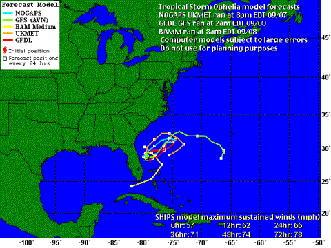
Figure 3. Early model track forecasts for Tropical Storm Ophelia, September 8, 2005.
Weak steering and low shear allowed Ophelia to continue to strengthen to 50 knot intensity as Ophelia made a slow, clockwise loop 110 miles east-southeast of Daytona Beach. Later on the afternoon of September 8, Doppler radar detected 80-85 knot winds at 6500 feet. A dropsonde measured a central pressure of 985 millibars and 15 knot surface winds suggesting an even lower surface pressure. NHC upgraded Ophelia to a 65 knot hurricane (Fig. 4) based on the radar and the in situ data. Reconnaissance flights later on September 8 found Ophelia's central pressure had risen to 991 millibar with a noticeable decrease in organization and a 20-30 knot southerly 250 millibar wind through the hurricane. Despite this late weakening trend and hostile upper air environment, NHC maintained Ophelia's 65 knot intensity until September 9.
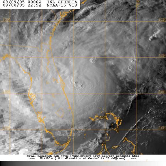
Figure 4. Hurricane Ophelia (65 knots, 990 millibar central pressure).
Ophelia was downgraded to a 55 knot Tropical Storm early on September 9 based upon a new aircraft reconnaissance report. Ophelia resumed a slow 4 knot meander northwards and was forecasted to re-intensify into a hurricane within 12 hours. Ophelia continued to show impressive convection and outflow throughout the day. Satellite intensity estimates and objective T-numbers kept Ophelia at hurricane strength, but later aircraft flights found only a 983 millibar central pressure and 72 knot winds at flight level. NHC forecast specialists upgraded Ophelia to a hurricane in the 5 PM discussion on September 9, despite the marginal intensity measurements reported by the reconnaissance aircraft. Weakening continued during the night of September 9 and Ophelia was back to a 60 knot Tropical Storm on the morning of September 10, slowly trudging northeastward at 9 knots, 240 miles southeast of Charleston, South Carolina. Model guidance continued to paint uncertainties into both the track and intensity forecast for Ophelia (Fig. 5). Despite these uncertainties, a hurricane watch was issued for the South Carolina coast at 11 AM, September 10th(Fig. 6).
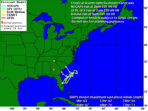
Figure 5. Model track forecasts for Tropical Storm Ophelia on September 9, 2005.
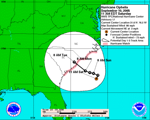
Figure 6. NHC forecast track issued September 10, 2005.
Ophelia became a 70 knot hurricane 210 miles east-southeast of Charleston, South Carolina during the afternoon of September 10 based upon a dropsonde measurement of 976 millibars and 78 knots at reconnaissance flight level. The hurricane slowed to 3 knots on an initial northeast track. Model forecast tracks on September 10 and the NHC official track, however, showed Ophelia making a closed loop, then making a turn to an ominous west-northwest recurving track with landfall along the South Carolina coast within 72 hours (Fig. 7). Figure 7 also showed a more cohesive model track consensus and hinted at future track shifts to the northeast when compared to previous forecast objective aids. Ophelia proceeded on a painfully slow, clockwise loop in the absence of any synoptic steering 230 miles east-southeast of Charleston, confounding forecasters and emergency managers in the Carolinas. Imagery on September 10th and 11th(Fig. 8) hinted at a less than favorable environment for Ophelia's intensification: an asymmetric, large eye, the absence of deep cohesive convection near the eye, dry mid-level air to the west and sheared convection north and east of Ophelia.
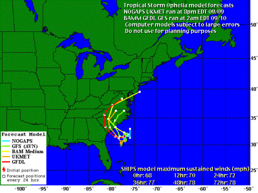
Figure 7. Model track forecasts for Tropical Storm Ophelia on September 10, 2005.
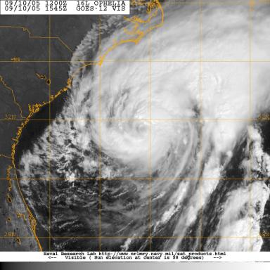
Figure 8. Tropical Storm Ophelia (60 knots, 976 millibar central pressure).
Ophelia's slow crawl over the Gulf Stream caused upwelling of cooler water, which acted to further constrain intensification (Fig. 9). Figure 10 shows the weakening caused by the upwelling and eyewall corruption due to dry air entrainment. NHC reclassified Ophelia as a 60 knot tropical storm on September 12. Ophelia did, however, remain a large storm with tropical storm force winds extending 140 miles from the eye (Fig. 10). NHC forecasters began to shift Ophelia's track northwards towards the South Carolina- North Carolina border.
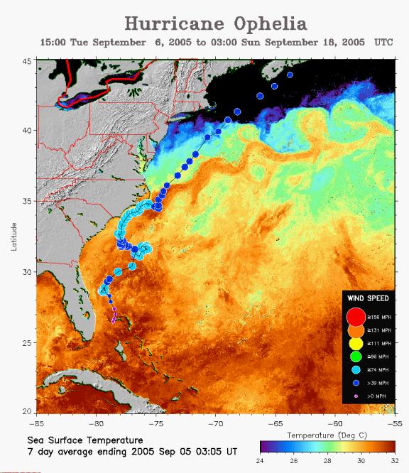
Figure 9. Hurricane Ophelias meandering track and problematic intensity changes over the Gulf Stream (Courtesy of NOAA and the University of Maryland).
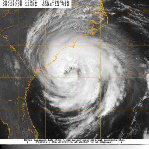
Figure 10. Tropical Storm Ophelia (60 knots, 989 millibar central pressure).
Ophelia continued a slow, erratic track to the northwest towards the South Carolina coast until the evening of September 13 when Ophelia regained minimal hurricane strength over warmer Gulf Stream waters. Ophelia turned to a more northerly track early, and paralleled the North Carolina coast, passing within 30 miles of Wilmington (maximum sustained winds 42 knots gusting to 59 knots) and brushing Cape Hatteras before turning east northeast on September 15 (Fig. 11). Ophelia was downgraded to a tropical storm for the last time on September 16 as it passed Cape Cod. Ophelia transitioned to an extratropical low on September 18 offshore Nova Scotia and ultimately dissipated over the North Sea September 23.

Figure 11. Wilmington, North Carolina based National Weather Service Doppler radar image of Hurricane Ophelia.
Ophelia's track forecast was dominated by the lack of westerly steering. Figure 12 shows Ophelia caught between the sub-tropical high to the east and a large quasi-stationary high parked over the eastern United States. These two features kept Ophelia confined offshore on a slow, meandering track northwards. Model resolution of Ophelia's track was inconsistent and problematic at best. The large, poorly organized eye complicated the task of accurately determining Ophelia's center of rotation. The lack of deep mean layer steering allowed Ophelia to perform two slow clockwise loops beneath the broad upper-level ridge.
The blocking highs which constrained Ophelia's meandering track also provided weak upper-level divergence. This upper level environment (Fig. 13) throttled Ophelia's intensity, keeping winds below 80 knots and central pressures above 972 millibars. Ophelia finally began to track northwards September 12 with the eastward retreat of the blocking high (Fig. 14) over the eastern United States and the approach of a cold front September 14 (Fig. 15).
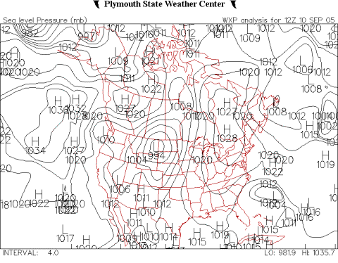
Figure 12. Surface pressure 12Z, September 10, 2005.
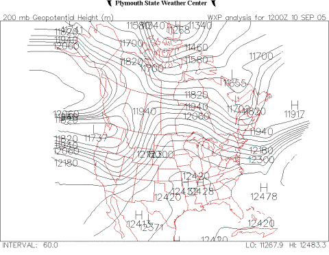
Figure 13. 200 millibar geopotential height 12Z, September 10, 2005.
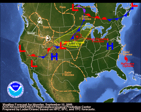
Figure 14. Surface Synoptic chart, September 12, 2005 (Courtesy NOAA HPC).
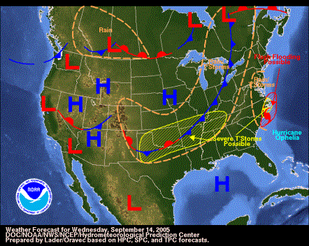
Figure 15. Surface Synoptic Chart, September 14, 2005 (Courtesy NOAA HPC).
Ophelia caused high surf and severe beach erosion at Hunting Island State Park on September 8. Numerous rip currents were reported along the coast from September 8-12; fortunately, there were no injuries reported.
Ophelia's outer rainbands brushed Georgetown and Horry counties September 12-14, causing downed trees, and minor coastal flooding on the sound side of the barrier islands.
The North Myrtle Beach Airport Automated Surface Observing System (ASOS) recorded 6.3 inches of rain falling September 12-14. North Myrtle Beach Airport also recorded 20 knot maximum sustained winds and a peak wind of 38 knots along with a minimum surface pressure of 1000.7 millibars. Figure 16 shows the surface pressure and winds recorded offshore at Frying Pan Shoals Buoy (41013) as Ophelia brushed the coast.
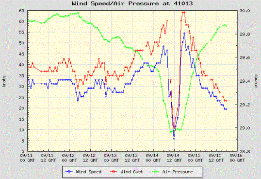
Figure 16. Frying Pan Shoals Buoy time series (NWS Forecast Office, Wilmington, NC).
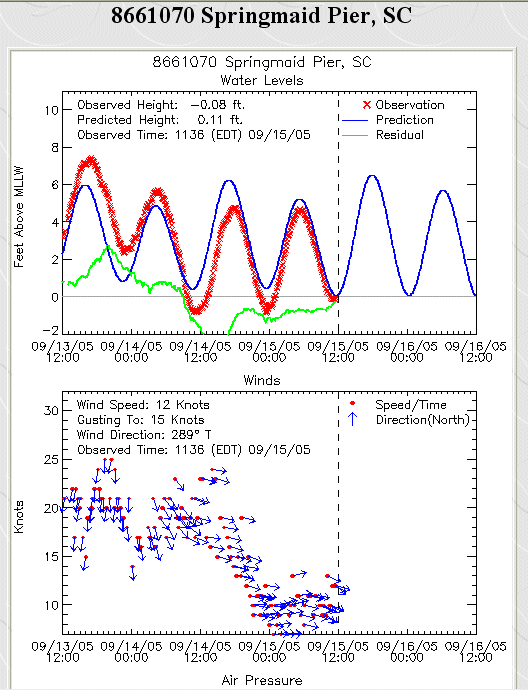
Figure 17. Springmaid Pier Data (Myrtle Beach, SC).
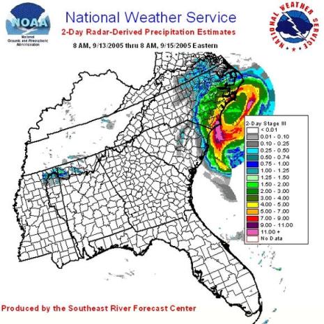
Figure 18. Radar derived rainfall estimates from Hurricane Ophelia.
Ophelia's erratic track and variable intensity produced a complex series of watches and warnings issued for the South Carolina coast:
The South Carolina Emergency Management Division activated the Emergency Operations Center on September 10 when the National Hurricane Center began forecasting Ophelia to make landfall on the South Carolina coast. The Emergency Operations Center remained staffed until September 14. There were no mandatory evacuations; however, Governor Sanford issued a voluntary evacuation for parts of Horry, Georgetown and portions of Charleston counties on September 12. The voluntary evacuation targeted people on barrier islands, oceanfront property, low-lying areas, and property along rivers and streams. People living in mobile homes and campgrounds within the targeted counties were also asked to evacuate voluntarily. Schools in coastal counties were closed as a precaution and several emergency shelters were opened when Ophelia threatened to make landfall September 11-14.
Unofficial peak wind gusts through 12 AM EDT Wednesday, September 14, 2005, from various observation sites in southeastern South Carolina.
| Location | Wind Speed (mph) |
Location | Wind Speed (mph) |
|---|---|---|---|
| Edisto Buoy(41004) | 69 | Ben Sawyer Bridge | 56 |
| Caro-COOPS Capers Midshelf | 51 | Arthur Ravenel BridgeDOT Sensor | 49 |
| Folly Beach (City Hall) | 44 | Downtown Charleston (Coast Guard Station) | 44 |
| Isle of Palms Police Department | 44 | Myrtle Beach Airport | 44 |
| Georgetown | 44 | Isle of Palms | 43 |
| Navy Tower R2 | 40 | Downtown Charleston | 39 |
| Folly Beach C-MAN (FBIS1) | 38 | Caro-COOPS Capers Island (CAP1) | 38 |
| Charleston Airport | 38 | Pineville (Lake Moultrie) | 37 |
| North Myrtle Beach | 37 | Goose Creek (Goose Creek High School) | 33 |
| Edisto Beach | 36 | North Charleston (Rivers Middle School) | 36 |
| Charleston (Burke High School) | 36 | Caro-COOPS Capers Nearshore | 33 |
| Caro-COOPS Fripp Inlet (FRP1) | 30 | Caro-COOPS Fripp Nearshore (FRP2) | 29 |
| Hilton Head (MESONET) | 29 | Beaufort County EM Office (WTOC MESONET) | 26 |
Special thanks to the National Oceanic and Atmospheric Administration and its many divisions for the wealth of weather and climate data made available to prepare this report. Specific thanks to:
Additional thanks to the Naval Research Laboratory Monterey's Marine Meteorology Division for the well cataloged library of satellite imagery used for this report.
Figures from the University of Maryland and Plymouth State College web sites were also used for this report.
