
Coastal Trawl Survey (CTS) and Data Management
Southeast Monitoring and Assessment Program – South Atlantic (SEAMAP-SA)

Field Sampling Methods
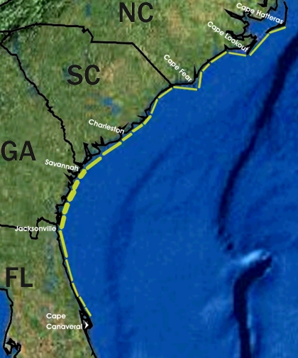
Samples are taken by trawl from the coastal zone of the South Atlantic Bight (SAB) between Cape Hatteras, North Carolina, and Cape Canaveral, Florida (Map of Coastal Trawl Survey sampling strata). Multi-legged cruises are conducted in spring (early April - mid-May), summer (mid-July - early August), and fall (October - mid-November).
Stations are randomly selected from a pool of stations within each stratum. The number of stations sampled in each stratum is determined by optimal allocation. A total of 102 stations are sampled each season within twentyfour shallow water strata, representing an increase from 78 stations previously sampled in those strata by the trawl survey (1990-2000). Strata are delineated by the 4 m depth contour inshore and the 10 m depth contour offshore. In previous years (1990-2000), stations were sampled in deeper strata with station depths ranging from 10 to 19m, in order to gather data on the reproductive condition of commercial penaeid shrimp. Those strata were abandoned in 2001 in order to intensify sampling in the more shallow depth-zone.
SEAMAP-SA Coastal Trawl Survey is provided in the Adobe PDF file format.