
DNR News** Archived Article - please check for current information. **
SCDNR declares temporary hunting closures for portions of Horry, Georgetown CountiesOctober 14, 2016
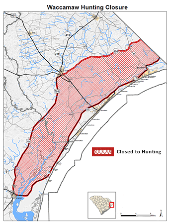
Map of Waccamaw Hunting Closure.
Due to the extremely high river levels and widespread flooding following Hurricane Matthew, the S.C. Department of Natural Resources (SCDNR) has declared a temporary closure for hunting within the Waccamaw River drainage system on all game species except for alligator, doves, hogs and coyotes. The flooding has created potential for exploitation of game species that are deprived of their normal escape routes and confined to small areas of high ground, and SCDNR has received concerns from multiple sportsmen.
Effective as of midnight on Saturday, Oct. 15, a ten-day closure of the hunting season for all game species excluding alligator, dove, hogs and coyotes will be in effect. The current closure will continue until midnight on Tuesday, Oct. 25, 2016. SCDNR will continue to monitor flooded areas to adjust the closure zones and timeframes as conditions change.
Waccamaw drainage:
HORRY COUNTY: West side boundary - beginning at the N.C. line on SC 905, thence down S.C. 905 to the intersection with U.S. 701, thence south on U.S. 701 to the Georgetown County line. East side boundary - beginning at the N.C. line on U.S. 17, thence down U.S. 17 to the Georgetown County line.
GEORGETOWN COUNTY: West side boundary - beginning at the Horry County line on U.S. 701, thence south to U.S. 17 in Georgetown. East side boundary - beginning at the Horry County line on U.S. 17, thence south on U.S. 17 to U.S. 701 in Georgetown.
For questions regarding the information in this article, contact Charles Ruth at 803-734-3886.
| Area | Personnel | Number |
|---|---|---|
| Coastal, Midlands | David Lucas | 843-610-0096 |
| Marine | Erin Weeks | 843-953-9845 |
| Upstate, Midlands | Greg Lucas | 864-380-5201 |
After Hours Radio Room - 803-955-4000