Tropical Storm Tammy
South Carolina Department of Natural Resources
Land, Water and Conservation Division
South Carolina State Climatology Office
Compiled by Mark Malsick
List of Figures:
Figure 1. Initial Wave disturbance.
Figure 2. Tropical storm Tammy.
Figure 3. Tammy at landfall 06 October, 2005
Figure 4. Tammy overland, prior to frontal absorption.
Figure 5. Surface synoptic situation 12Z 05 October, 2005.
Figure 6. 300 millibar streamlines 00Z 05 October, 2005.
Figure 7. 300 millibar divergence 00Z 05 October, 2005.
Figure 8. 500 millibar streamlines 00Z 05 October, 2005.
Figure 9. 850 millibar streamlines 00Z 05 October, 2005.
Figure 10. 1000 millibar streamlines 00Z 05 October, 2005.
Figure 11. Estimated October 2005 South Carolina rainfall distribution.
Figures 12a-b. Edisto Beach damage.
EVENT SUMMARY:
Tammy began as a weak easterly wave that tracked slowly
across the Atlantic and became a persistent quasi-stationary wave over the
Bahamas until the US Navy issued a Tropical Cyclone Formation Alert (TCFA) for
the disturbance at 23oN 074.5oW. This disturbance had menaced the Bahamas for
the previous 48 hours with 30 knot winds (Fig. 1). Early in the morning of
October 5, 2005,National Weather Service Radar and 30 knot buoy observations indicated a rapidly developing,
well-defined surface circulation in a broad tropical disturbance 40 miles east
of Melbourne, Florida, that was quickly upgraded to Tropical Storm Tammy based
on 35 knot winds embedded in deep convection contained in the northeast
quadrant (Fig. 2.) of the season's twenty-first storm. Coastal proximity
(<50 nm) of a rapidly developing Tammy forced the accelerated classification
of this new storm.
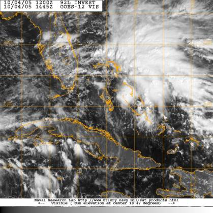
Figure 1. Initial wave disturbance that became Tropical Storm Tammy.
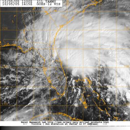
Figure 2. Tropical Storm Tammy.
Tammy rapidly moved north, parallel to the Florida coast, at
14 knots passing over NOAA buoy 41009 which measured a central pressure of
1004mb.Tammy's asymmetrical convection
hindered accurate center fixes, which complicated the track forecast. Aircraft
recon later on the 5 measured peak fight level winds of 53 knots 150 nautical
miles northeast of Tammy's center. This
measurement and 50-55 knot visual estimates supported surface wind estimates of
45 knots. Motion estimates of Tammy were now 330 at 12 knots.
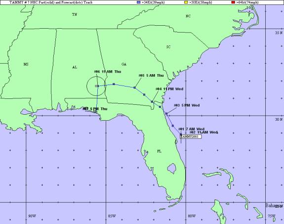
Tammy quickly made landfall by 9 PM October 5 in the
vicinity of Mayport, Florida, with 35 knot winds and heavy rain, particularly
in the northern semi-circle (Fig. 3). Tammy rapidly lost intensity while over
south central Georgia as it slowed and spread heavy tropical rain bands into
the Georgia coastline and South Carolina. Tammy was downgraded to a Tropical Depression at 11AM October 6 as it
lurched slowly westward into southern Alabama where Tammy was absorbed within
an cold frontal boundary. This frontal boundary sheared Tammy rapidly and
spread a large plume of heavy tropical convective debris that would affect
South Carolina and other coastal states northeastward into New England with
deadly and devastating flooding.
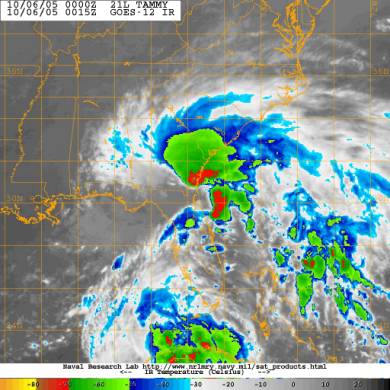
Figure 3. Tammy at landfall 06 October 2005.
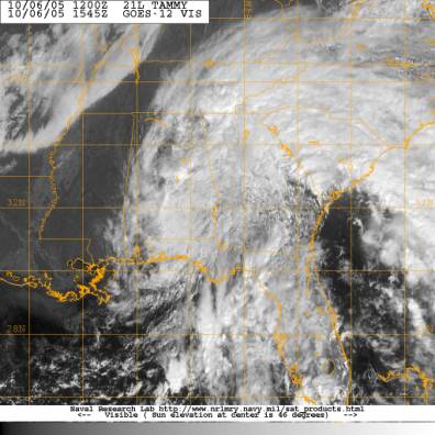
Figure 4. Tammy overland prior to frontal absorption.
FORECAST CONSIDERATIONS:
Tammy was a surprising, short duration coastal storm that intensified from a persistent tropical wave into a minimal storm between an upper level low over the eastern Gulf of Mexico and the southwestern boundary of the Atlantic sub-tropical high. These synoptic features provided a lively north-northwesterly steering along the Florida coast on the morning of October 5 until landfall. (Fig. 5) Strengthening of the sub-tropical high provided a more westerly component for Tammy's track until Tammy was absorbed by an approaching frontal boundary.
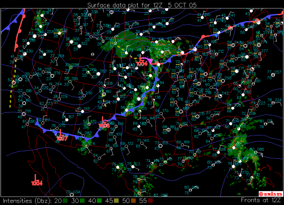
Figure 5. Surface synoptic situation 12Z 05 October 2005.
The rapid intensification of Tammy can be attributed to Florida's warm, coastal waters,abundant low level relative vorticity associated with the disturbance lingering over the Bahamas prior to October 5 and upper level divergence at 300mb (Figures 6 and 7). A large 500mb cyclone (Figures 8-10) over Arkansas provided the shallow mean level steering, forcing Tammy quickly inland.Persistent upper level shear prevented Tammy from intensifying above Tropical Storm strength during its short life over warm Florida waters. Upper level shear was also responsible for Tammy's asymmetric circulation and deep convection concentration in the northeast semi-circle.
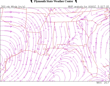
Figure 6. 300 millibar streamlines 00Z 05 October 2005.
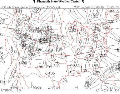
Figure 7. 300 millibar divergence 00Z 05 October 2005.
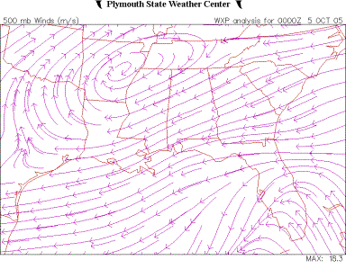
Figure 8. 500 millibar streamlines 00Z 05 October 2005.
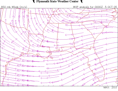
Figure 9. 850 millibar streamlines 00Z 05 October 2005.
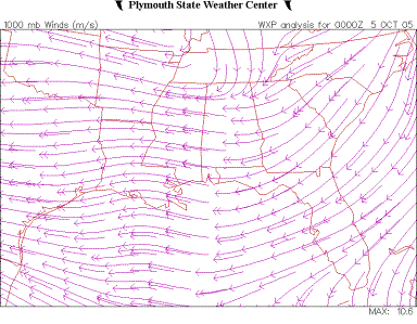
Figure 10. 1000 millibar streamlines 00Z 05 October 2005.
SOUTH CAROLINA EFFECTS:
Prior to and upon landfall Tammy spread a large precipitation shield over South Carolina (Figures 3 and 4). The strongest winds and convection were also in the northern quadrants of Tammy. Event rainfall maxima in excess of 10 inches were measured in the vicinity of Georgetown and Spartanburg, South Carolina. Widespread flooding, downed trees and power lines were widely reported throughout the State.
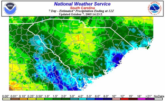
Figure 11. Estimated October 2005 South Carolina rainfall distribution.
Significant beach erosion was reported along the coast with
heavy erosion occurring at Edisto Beach where several feet of beach were lost.
Beach erosion also occurred along the coast at The Isle of Palms, Tybee Island
and Hunting Island. High tide and pounding surf were responsible for the
destruction of at least one house at Edisto Beach (Fig. 12b). Six to eight Edisto city blocks were closed due to sand and debris that blocked roads.
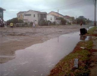
Figure 12a. Edisto City Beach damage.
(Photo by Delaine McJunkin)
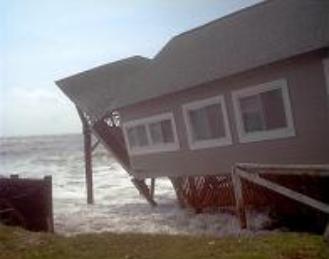
Figure 12b. Edisto City Beach damage.
(Photo by Delaine McJunkin)
Gusty winds blew down 30 trees in Beaufort County. Scattered tree damage was reported along the coast. No tornados were reported during the passage of Tammy's convective
debris.The South Carolina Emergency Operations Center was not activated for Tropical Storm Tammy.
TROPICAL STORM TAMMY WIND AND RAINFALL REPORTS:
Recorded Winds:(unofficial)
Edisto Beach (NWS site)                         59 MPH...51 Knots
Folly Beach (C-Man buoy FBIS1)                  54 MPH...47 Knots
Edisto Buoy (41004)                             54 MPH...47 Knots
Port Authority Crane (CharlestonCounty)         50 MPH...44 Knots+++
Downtown Charleston (CHL)                       49 MPH...43 Knots
Ravenel Bridge (Charleston County)              48 MPH...42 Knots+++
Fripp Island                                    48 MPH...42 Knots
Downtown Charleston (Coast Guard Station)       47 MPH...41 Knots
Ben Sawyer Bridge DOT sensor                    47 MPH...41 Knots
Folly Beach City Hall                           47 MPH...41 Knots
Hilton Head (Salty Dog Cafe)                    45 MPH...39 Knots
Charleston (KCHS)                               42 MPH...36 Knots
Goose Creek High School                         42 MPH...36 Knots
Burke High School (Charleston County            41 MPH...35 Knots
Savannah (RAWS site Jasper County)              41 MPH...35 Knots
Beaufort (Media MESONET)                        39 MPH...34 Knots
Rivers Middle School (CharlestonCounty)         38 MPH...33 Knots
Beaufort (NBC)                                  37 MPH...32 Knots
Hilton Head (HXD)                               35 MPH...30 Knots
Isle of Palms                                   35 MPH...30 Knots
Lambs Elementary School (Charleston County)     34 MPH...29 Knots
Mitchell Elementary School (Charleston County)  32 MPH...28 Knots
+++ Observation estimated at about 200 feet.
Precipitation Totals:
Division Name: Mountain
                                        Precipitation (inches)
                                        Obs      1-Day Max       Date
Caesars Head                            3.15       1.32          10/6
Hunts Bridge                            1.67       0.84          10/7
Travelers Rest                          3.90       1.90          10/7
Division Name: Northwest
Anderson County Arpt.                   3.58       2.71          10/6
Clinton                                 7.48       5.68          10/8
Gaffney                                 6.31       4.38          10/8
Greenville-Spartanburg Arpt.            4.12       2.13          10/7
Laurens                                 6.70       5.35          10/8
Lockhart                                3.90       2.90          10/8
Pickens                                 2.07       1.50          10/7
Sandy Springs                           3.28       1.85          10/7
Union                                   4.11       2.67          10/8
Walhalla                                3.02       2.12          10/7
West Pelzer                             3.49       1.76          10/8
Division Name: North Central
Chester                                 2.77       0.93          10/8
Fort Mill                               2.86       1.18          10/8+
York                                    3.86       2.37          10/8
Division Name: Northeast
Andrew                                 11.51       7.60          10/7
Cades                                   4.81       2.98          10/7
Cheraw                                  3.41       2.42          10/7
Dillon                                  3.70       2.50          10/7
Effingham                               4.45       2.81          10/7
Florence                                3.84       2.91          10/7
Florence Regional Arpt.                 3.17       2.14          10/6
Georgetown                             14.88       6.98          10/7
Hartsville                              3.10       1.83          10/7
Hemingway                               9.40       6.75          10/7
McColl                                  5.32       3.01          10/6
Mullins                                 4.20       2.85          10/7
Division Name: West Central
Aiken                                   5.25       2.61          10/8
Calhoun Falls                           3.51       1.63          10/7
Chappells                               5.44       3.51          10/8
Clark Hill                              5.97       2.48          10/7
Johnston                                3.52       1.14          10/8
Saluda                                  3.95       1.80          10/8
Division Name: Central
Bishopville                             1.98       0.61          10/6
Cedar Creek                             1.46       0.58          10/6
Columbia Metro. Arpt.                   2.45       1.09          10/6
Columbia USC                            1.07       0.73          10/6
Sandhill Research                       1.88       0.75          10/6
Sumter                                  2.34       0.83          10/7
Division Name: Southern
Beaufort WWTP                           4.23       2.20          10/6
Charleston City                         3.44       1.56          10/7
Charleston Intl. Arpt.                  3.65       1.44          10/5
Givhans Ferry                           3.13       1.44          10/6
Jamestown                               8.60       4.20          10/6
Santee COOP Spillway                    4.07       2.14          10/6
Sullivans Island                        3.70       1.53          10/7

Flag Information:

    +  = indicates extreme also occurred on other dates (last date listed)
ACKNOWLEDGEMENTS:
Special thanks to the National Oceanic and Atmospheric
Administration and its many divisions for the wealth of weather and climate
data made available too prepare this report. Specific thanks to:
- National Hurricane Center, Miami, Florida
- National Weather Service Office, Charleston, South Carolina
- National Weather Service Office, Columbia, South Carolina
- National Weather Service Office, Wilmington, North Carolina
Additional thanks the Naval Research Laboratory Monterey's
Marine Meteorology Division for the well cataloged library of satellite imagery
used for this report.
Figures from the Plymouth State College and the UNISYS web
sites were also used for this report.