
Current WMA Maps
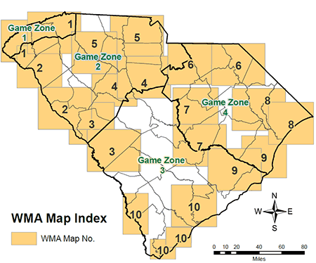
Find your Map
| Game Zone | Wildlife Management Area Maps (Adobe PDF files) |
|||||||||
|---|---|---|---|---|---|---|---|---|---|---|
| 1 | 2 | 3 | 4 | 5 | 6 | 7 | 8 | 9 | 10 | |
| 1 | X | |||||||||
| 2 | X | X | X | X | X | |||||
| 3 | X | X | X | X | X | |||||
| 4 | X | X | X | X | X | |||||
Please note: The WMA Maps which are Adobe PDF files range in file size from 4M to 8M.
Various sources were used to produce the WMA maps using geospatial information.
The WMA maps listed above are in the Adobe PDF file format. Adobe® Reader® is required to open the files and is available as a free download from the Adobe® Web site.
![]()
Contact to Request a Map:
Individual mailings are limited to 3 maps.
WMA Maps
P.O. Box 167
Columbia, SC 29202
803-734-3886