
ACE Basin NERR
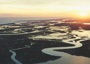 The ACE Basin area was designated as a National Estuarine Research Reserve (NERR) by NOAA in 1992. As with all of the 28 protected areas in the NERR System, it was established to promote long-term research, education, coastal training, and stewardship. It is the third largest reserve in the nation and is one of the largest undeveloped estuaries on the East Coast. The ACE Basin is named for the Ashepoo, Combahee and Edisto rivers, which meander past pine and hardwood uplands, cypress swamps, extensive waterfowl impoundments, expansive fresh, brackish and salt water tidal marshes, isolated barrier islands and pristine beaches to meet in the biologically rich St. Helena Sound. Headquartered 45 minutes south of Charleston, South Carolina, the reserve encompasses parts of Colleton, Charleston, Beaufort, and Hampton counties. The Reserve protects 98,308 acres of the natural beauty, abundant wildlife and unique cultural heritage of the area. In addition, the Reserve preserves habitat for many endangered or threatened species, such as shortnose sturgeon, wood storks, loggerhead sea turtles and bald eagles. Additional information regarding the ACE Basin NERR.
 Research directly related to the management of the ACE reserve's resources is actively encouraged and is a high priority. Numerous research and monitoring projects (including cumulative environmental impacts, contaminant assessments, population assessments and environmental stress indicators) have been conducted by government agencies, academic institutions and private organizations in or adjacent to the ACE Basin NERR. The Research Sector of the ACE Basin NERR operates an extensive environmental research and monitoring program that provides significant infrastructure and databases for collaborating visiting scientists. Research questions for which the Sector seeks partners focus on:
- freshwater/saltwater dynamics in the major ACE Basin tributaries,
- mechanisms of marsh response and marsh retreat to changes in sea level, inundation regimes, and weather patterns,
- critical habitat identification and delineation.
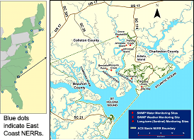
The purpose of the monitoring program at the ACE Basin NERR is to document both short-term variability and long-term changes in the water quality, biotic diversity, and land-use/land-cover characteristics of estuaries with the goal of informing coastal zone managers about the dynamics of estuarine ecosystems. This goal, shared by all of the 28 NERR sites around the country, is incorporated into a coordinated research effort and forms the basis of the NERRS System-Wide Monitoring Program (SWMP: pronounced "swamp"). SWMP provides a long-term data set of selected water quality and meteorological parameters collected at NERR sites nationwide. Archived and real-time SWMP data are available to the public.
Program Leader:
Dr. Denise Sanger
Phone: 843-953-9074