
Great Pee Dee River
In 2002, the lower 70-mile segment of the Great Pee Dee was designated a State Scenic River. This designation extends from the US Highway 378 Bridge crossing between Florence and Marion Counties to the US Highway 17 Bridge at Winyah Bay in Georgetown County.
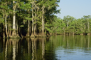
The Great Pee Dee is large and wild. It is a Coastal Plain river that offers diverse scenery along winding water trails lined by swamps, bottomland forests, coastal marsh, and historic structures. The river floodplain and adjacent uplands contain large acreages of wild and undeveloped forestland, wetlands, and open waters that provide excellent habitat for a variety of wildlife species; and the free-flowing, unaltered river system is an important habitat for resident and migratory fish species. These natural conditions of the Pee Dee River provide recreational boating and fishing opportunities and many other nature-based recreations that are valued by the public.
Partners for South Carolina Scenic River Projects serve on local advisory councils that represent local landowners, river users, community interests, and SCDNR. The Great Pee Dee and the adjoining Little Pee Dee are two State Scenic Rivers which the DNR has merged into one Project with one advisory council. The combined advisory council, called the Pee Dee Scenic River Advisory Council, includes members representing both scenic rivers. Participation has included resident property owners, Georgetown County Historical Society, SC Coastal Conservation League, Red Mountain Timber Company, Georgetown County, Pee Dee River Watchers, Wildlife Action, Winyah Rivers Foundation, The Nature Conservancy, US Fish and Wildlife Service, Baruch Institute, Coastal Carolina University, and SCDHEC.
A 2014 public opinion survey identifies how citizens use and enjoy this river and what they think needs to happen to manage this river into the future. For details see:
Summary of Pee Dee Scenic Rivers Public Opinion Survey of May-June 2014
(PDF)
Recreation & Access
The entire 70-mile scenic river segment is navigable (free enough to be traveled upon by a small vessel) and may be accessed from a number of public boat landings dispersed along its length. The lower sections of the river are used by large powerboats. Small powerboats and canoes are commonly used to navigate the narrow abandoned channels and oxbow lakes. Opportunities for multi-day canoe-camping trips are available during normal to low water conditions when the large sand bars along the upper portions of the river offer camping sites.
Those who fish the Great Pee Dee are known to seek a variety of species throughout the length of the river in a mix of fresh and salt water environments. Freshwater fishes sought by anglers include various catfish, bass, bream, and shad species, also bowfin, carp, and gar. Saltwater fishes include red drum, black drum, seatrout, mullet, and flounder, as well as shrimp and blue crab. Note that mercury contamination of fish is a widespread impairment of streams in South Carolina and the nation, and a fish consumption advisory (recommended limits on the eating of certain fish) is in effect for largemouth bass, redear sunfish, blue catfish, and bowfin caught in the Great Pee Dee River. See DHEC's fish consumption advisory page.
Public access sites along the Great Pee Dee Scenic River are listed below in order from upstream to downstream locations.
Allisons (Ellisons or Poston) Landing – This site is located on the Great Pee Dee at the end of Allison Landing Road (State Road 99) in Florence County. The facility provides a ramp, courtesy dock, and parking on the west/south side of river, about 3.5 river miles downstream of the US Hwy 378 Bridge. Downstream distance from this site to the next landing at Dunham Bluff is about 6 river miles
Dunham Bluff Landing - This site is located on the Great Pee Dee in Marion County at the end of Dunham Bluff Road, a road which adjoins US Hwy 378 opposite the Park n' Blow Handi Mart. This landing provides a ramp and parking on the east/north side of river, and the site is located within the Woodbury Wildlife Management Area. The downstream distance from this site to the next landing at Staple Lake is about 9 river miles
Woodbury Wildlife Management Area and Heritage Preserve – This area consists of 25,668 acres managed for wildlife and recreation and is located at the south end of Marion County between the Great Pee Dee and Little Pee Dee Scenic Rivers. Entrances to Woodbury WMA/HP are located off US Hwy 378 on Woodbury Road or Pet Larrimore Road, and are marked with brown reflective signs. Hunting, fishing, boating, birding, hiking, biking and wildlife viewing are among the more popular activities enjoyed by visitors. Boat ramps within this property are located at Dunham Bluff and Tan Yard landings which access the Great Pee Dee River, and at Sampson, Sanders and Parker landings which accesses tributaries and side channels to the Little Pee Dee River.
Staple Lake Landing – This landing accesses the Great Pee Dee via a side channel called Staple Lake, and the site is located east of Hemingway in Williamsburg County. From State Road 261 at Outland, dive northeast on County Line Road (State Road 5) for about five miles to the landing. This landing provides a ramp and a parking area on the south side of Staple Lake about 300 yards from the Great Pee Dee River channel. This landing is about 19 river miles below US Hwy 378 Bridge. Downstream distance from this site to the next landing at Port Hill is about 6 river miles.
Upstream of Staple Lake Landing, portions of the Great Pee Dee and the Lynches River have been designated The Revolutionary Rivers National Recreation Trail of South Carolina in recognition of the historic and recreational values of these rivers.
Port Hill Landing - This site is located at the end of Ports Hill Drive in Georgetown County on the west/south side of the Great Pee Dee. No parking is provided at this site, and at low water levels the ramp is unusable to all but canoes and other small boats. Downstream distance from this site to the next landing at Petersfield is about 4 river miles.
Petersfield Landing - This site is at the end of Petersfield Landing Road, which extends north off Old Pee Dee Road (State Road 36) in Georgetown County. The facility provides a ramp, courtesy dock, and parking on the west/south side of the Great Pee Dee River. This landing is about 29 river miles below the US Hwy 378 Bridge. Downstream distance from this site to the next landing at Tan Yard is about 7 river miles.
Tan Yard Landing – This site is within the Woodbury Wildlife Management Area and Heritage Preserve, and located at the end of Woodbury Road, which is a 14-mile drive south from US Hwy 378 in Marion County. This site provides a dirt landing and parking area. It’s location on the Great Pee Dee River is about 36 river miles below the US 378 Bridge, about half a river mile above the confluence with the Little Pee Dee River. Downstream distance from this site to the next landing at Yauhannah is about 5 river miles.
Yauhannah Landing – This site is at the base of the US Hwy 701 Bridge in Horry County. The facility provides a ramp, courtesy dock, and parking area on the east side of the Great Pee Dee River. This landing is about 41 river miles below the US Hwy 378 Bridge, and 29 river miles above the US Hwy 17 Bridge at Winyah Bay. One-half mile downstream of US Hwy 701 Bridge, the river channel diverges to form Bull Creek, which initially runs to the east, while the Great Pee Dee channel makes a hard right turn to the south. Approximately 1 mile to the east on Bull Creek is the Port Harrelson Landing.
Waccamaw National Wildlife Refuge - This refuge encompasses nearly 29,000 acres along the Great Pee Dee and Waccamaw rivers. A Visitors Center for the refuge is adjacent to US Hwy 701 at the community of Yauhannah in Georgetown County and sits on the west bluff of the Great Pee Dee overlooking the river and provides a dock for visiting river travelers. Along the river this site is about 1 mile south/west from where the Great Pee Dee and Bull Creek channels diverge.
Port Harrelson Landing – This site is on Bull Creek and located at the end of Big Bull Landing Road, which extends south from Port Harrelson Road in Horry County just west of Bucksport. The facility provides a ramp, courtesy dock, and parking. As described above, this landing is located on Bull Creek about 1 mile east from the Great Pee Dee River channel.
Downstream boating distance from either Yauhannah or Port Harrelson landing to the next landing at Samworth Wildlife Management Area is about 18 river miles on the Great Pee Dee.
Samworth Wildlife Management Area – Located on the west side of the Great Pee Dee River in Georgetown County, this area may be accessed from Plantersville Road (State Road 52) via Samworth Loop and Dirleton Road. This property features the Dirleton Plantation House, a public boat ramp with parking, and recreation opportunities to include hunting, fishing, bird watching, nature trails, and a canoe-kayak access to the river.
Adjacent to Samworth WMA is the Pee Dee River Rice Planters' Historic District which includes buildings, structures, and ricefields associated with 12 historic rice plantations located along the Great Pee Dee River.
The downstream distance, going south from Samworth Wildlife Management Area to the US Hwy 17 Bridge at Winyah Bay is about 10 river miles. Beyond Hwy 17 Bridge, at the City of Georgetown launch sites are available at either East Bay Street Landing or the Campbell Marine Complex and may be useful to boaters on the Great Pee Dee.
Across the river from Samworth Wildlife Management Area, and across the two-mile expanse of tidal marshlands, there are public landings on the Waccamaw River that can provide additional access opportunities to the lower reaches of Great Pee Dee River system. The Waccamaw River sites to consider are Sandy Island Landing and Hagley Landing, both in Georgetown County and accessed from roads off Ocean Highway (US Hwy 17) near Pawleys Island.