Aerial Surveys for Waterfowl and Other Waterbirds
Wildlife biologists from Clemson University's James C. Kennedy Waterfowl and Wetlands Conservation Center and the South Carolina Department of Natural Resources conduct aerial surveys of waterfowl and other waterbirds from Murrells Inlet to the South Carolina-Georgia border and inland including the Cooper River and Santee Lakes system.
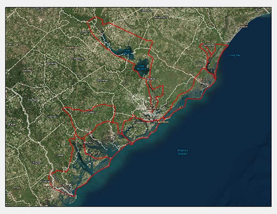
Surveys currently cover nine wetland regions in the state.
The purposes of surveys are to estimate abundance and species diversity of waterfowl and other waterbirds and monitor dynamic habitat use amid climate change, sea level rise, and human developments in South Carolina through time. Survey protocols were developed by Drs. Aaron Pearse, Steve Dinsmore, Richard Kaminski, and Ken Reinecke of Mississippi State University for the Mississippi Department of Wildlife, Fisheries, and Parks. The protocols also have been adopted by other states in the Lower Mississippi Valley. These are the first aerial transect surveys in South Carolina and the Atlantic Flyway inland from the coast.
Surveys are conducted mid-monthly in September and continue from November-March. Additional surveys may be added pending available funding. Fixed-winged aircraft are used to fly surveys along randomly selected east-west transects. Flights are conducted at low altitudes of ~200 feet above ground to enable identification of waterfowl and waterbird species. Flights at this altitude minimally disturb waterfowl, because only single passes over wetlands occur along selected transects.
During flights, a survey biologist counts all waterfowl and waterbirds seen within a ~300 yard-wide strip along the right side of the aircraft. Each individual or group of waterfowl and waterbirds detected within the strip are recorded on a Global Positioning System to generate maps depicting densities of sighted birds by habitat type. At the conclusion of the survey, biologists use densities of sighted birds to calculate estimates of abundance in the survey regions. Information derived from these surveys serve to identify key habitats for wetland birds across South Carolina. Public and private-sector biologists, scientists, waterfowl hunters, and other conservationists use this information for assessing current use of habitats, for tracking waterfowl movements in response to weather, habitat changes, and human development, and for guiding future habitat conservation initiatives.
Sponsors and partners of this research are the Delta Waterfowl Foundation, Ducks Unlimited, Inc., the James C. Kennedy Waterfowl and Wetlands Conservation Center of Clemson University, Mississippi Department of Wildlife, Fisheries and Parks, Nemours Wildlife Foundation, South Carolina Department of Natural Resources, South Carolina Waterfowl Association, and the U.S. Fish & Wildlife Service.
For more information please contact Dr. Rick Kaminski, Kennedy Center Director at rmkamin@clemson.edu or Molly Kneece, Survey Biologist at KneeceM@dnr.sc.gov.
Aerial Waterfowl and Waterbirds Survey Report - November 2016