
GIS Data Resources
Comprehensive Spatial Database on SC's Coastal Resources and Uses
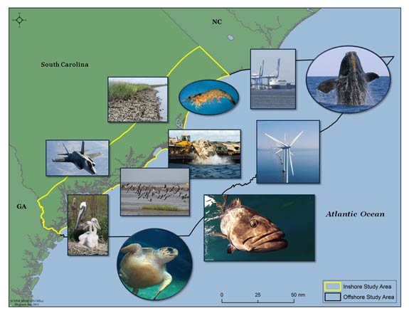
Marine Resources Division personnel have recently developed a comprehensive spatial database on South Carolina's Coastal Resources and Activities through funding from the South Carolina Energy Office.
The goal of this project was to provide the most up-to-date information on:
- the distribution of habitats,
- biological resources, and
- human use data.
The study region covers the area between the South Carolina-Georgia border (32°N) to just north of the South Carolina-North Carolina border (34°N), and between 30 miles inland to the 200 m bathymetric depth contour. All of the data layers can be downloaded by the public from the DNR's GIS data resources site.
Examples of the more than 70 data layers available include:
- Habitat resources - hydrography, land cover, offshore wind speed, and state and federal protected lands,
- Biological data - bird and turtle nesting areas, marine mammal, finfish, and juvenile sea turtle distributions, and
- Human Use – jurisdictional boundaries, shipping activities, military use areas, commercial fishing distribution, and areas used for ocean disposal or sand mining for beach nourishment.
Project Contact
These data products are made possible by the South Carolina Department of Natural Resources and other State, Federal, and Local government entities in South Carolina in support of this project.
If you have any questions please contact:
Dawn Misura,
South Carolina Department of Natural Resources
Marine Resources Division
Geographic Coordinate System
UTM, Zone 17, Meters, Datum NAD83
Viewing Data
To view the GIS data, you will need computer mapping software.
For users without GIS desktop software, a free desktop viewer from ESRI is available, ArcGIS Explorer. The Resource Center for ArcGIS Explorer from ESRI provides tutorials, Online Help, forum, and related documentation. The TatukGIS Viewer is a free viewer available from TatukGIS.
For other software programs, please consult your particular software's help to determine compatibility with this format and any required software updates and/or plugins.
Download Available Data
Data is available for download at no cost from DNR's ftp site. Last updated October 2011.
- SC Comprehensive Spatial Database Final Report
- ESRI ArcGIS v9.3 file geodatabase: SCCoastalGeodatabase.zip
- LiDAR data
Additional Data Resources
- NAIP Imagery (available through USDA's Geospatial Data Gateway or ArcGIS Server connection).