
Black Scenic River
A 75-mile segment of the Black River was designated a State Scenic River in June 2001. This Scenic River designation extends from State Road 40 Bridge (June Burn Road) in Clarendon County, through Williamsburg County, and ends at Pea House Landing in Georgetown County.
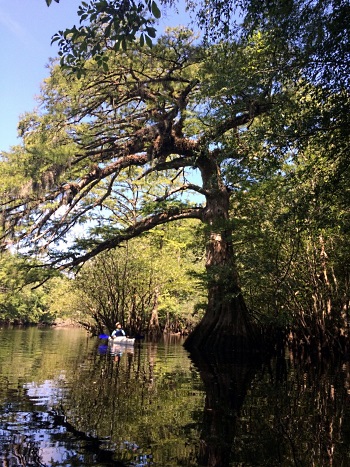
The Black is a free-flowing Coastal Plain river bordered by a rural landscape of forests and farmlands. The river corridor presents a ribbon of dense swamp forests, dark waters, and white sandbars. The Black River is named for its black water, darkly stained and resembling a tea or coffee color, which results from the tannins leached from plant material in the surrounding swamps. The channel pattern of the Black River alternates from large, open "lake-like" areas to narrow channels.
The river and adjacent lands provide a corridor of high quality habitat for a variety of plants and animals including some rare species such as American chaffseed and the swallow-tailed kite, and some very old species such as the bald cypress trees growing near The Nature Conservancy’s Black River tract east of Andrews.
Partners for the Black Scenic River Project serve on a local advisory council that represents local landowners, river users, community interests, and SCDNR. Participation has included Williamsburg Hometown Chamber Quality of Place Committee, Conservation Districts, Wildlife Action, SCDHEC, SC Forestry Commission, USDA-NRCS, Black River Cypress Preserve, Main Street Kingstree, Pee Dee Land Trust, Lowcountry Land Trust, and the County Councils of Williamsburg, Clarendon, and Georgetown counties.
The Black Scenic River Management Plan was completed in November 2020 by the Black Scenic River Advisory Council and SCDNR. The plan serves as a guiding document for the advisory council and specifies goals and recommendations to address stewardship of the river and related issues of history and cultural resources, land use, wildlife, water quality, streamflow, recreational use, and public access.
Recreational Access
The Black Scenic River may be explored from informal access points and public boat landings, which are listed below in order from upstream to downstream locations.
June Burn Road (State Road 40) bridge – This site on the Black River in Clarendon County is limited to carry-in boat access at a bridge within the highway right-of-way. Note, the river has 5 or 6 channels at this location with a larger channel at the middle. Distance from this site to the next access location at Mt Vernon Road (State Road 35) bridge is about 12 river miles.
Pocotaligo River landing at N. Brewington Road (State Road 50) bridge – This public landing provides an alternative entrance to the upper Black River, and is located in Clarendon County on the Pocotaligo River about three miles upstream from its confluence with Black River. Distance from this landing to the next Black River access location at Mt Vernon Road (State Road 35) bridge is about 10 river miles.
Mt Vernon Road (State Road 35) bridge - This site on the Black River in Williamsburg County is limited to carry-in boat access at the bridge within the highway right-of-way. Distance from this site to the next access location at Gilland Memorial Park at Kingstree is about 15 river miles.
Gilland Memorial Park and landing - This public park on Black River includes a playground, picnic shelter, and swim area at the river on a sandy beach, restroom facilities, parking areas, and a boat ramp. The park is located at the end of Singleton Avenue off US Hwy 52 in Kingstree.
Mill Street Landing – This site provides a public boat ramp with parking and is located in Kingstree at the end of Mill Street off US Hwy 52. Distance from Gilland Park or Mill Street Landing to the next access location at SC Hwy 377 Bridge is roughly 9 river miles.
SC Highway 377 bridge - This site is limited to carry-in boat access at the bridge within the highway right-of-way. Distance from this site to the next access location at Simms Reach Road (State Road 30) bridge is about 12 river miles.
Simms Reach Road (State Road 30) bridge - This site is limited to carry-in boat access at the bridge within the highway right-of-way. Distance from this site to the next access location at Ervin Park is about 10 river miles.
Ervin Park and landing – This public park on the Black River includes a picnic shelter, parking area, and boat ramp. The park is located at the end of Ervin Road (State Road 688) off SC Hwy 527. Distance from this site to the next access location at Pump House Landing is about 10 river miles.
Pump House Landing at Reds Landing Road – This public landing is just downstream of the SC Highway 41 bridge in Andrews and includes a parking lot and boat ramp. The site is located at the end of Reds Landing Road off SC Hwy 41. Distance from this site to the next access location at Pine Tree Landing is about 5 river miles.
Pine Tree Landing - This public landing includes a parking area, dock, and boat ramp. The site is on the north side of the river on a side channel, and not easily seen from the main river channel. It’s located at the end of Pine Tree Landing Road off Big Dam Swamp Road (State Road 38) in Georgetown County. Distance from this site to the next access location at Pea House Landing is about 5 river miles.
Pea House Landing - This public landing includes a parking area, dock, and boat ramp. The site is located at the end of Big Dam Swamp Road (State Road 38) in Georgetown County. The State Scenic River designation ends at Pea House Landing.
Further down the Black River - From Pea House Landing, the Black River flows for another 38 river miles through Georgetown County to its confluence with the Great Pee Dee River. Access sites along the lower 38-mile section include 5 public landings: Old Pumping Station, Browns Ferry, Rocky Point, Peters Creek, and Pringles Ferry.