
Little Pee Dee River of Dillon County
The Little Pee Dee River in Dillon County was designated a State Scenic River in 2005. The section designated as a scenic river extends 48 river miles through Dillon County from the Marlboro County line above Parish Mill Bridge on State Road 363 to the confluence with Buck Swamp at the Marion County line.
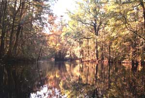
The Little Pee Dee is a classic blackwater river and provides outstanding scenery with clear dark waters, sandy river bottoms and bars, and winding water trails lined by cypress-tupelo swamps and bottomland hardwood forests. The natural resources of the Little Pee Dee River provide outstanding recreational fishing and boating opportunities and many other nature-based recreations.
The Little Pee Dee River floodplain and adjacent uplands contain large acreages of wild and undeveloped forestland, wetlands, and open waters that provide important habitat for a great variety of wildlife species. The adjacent uplands contain additional wildlife habitat in a landscape of agricultural fields and upland forests. The free flowing, unaltered river system is an important resource for inland fisheries with its streams, sloughs, oxbow lakes, and swamps providing diverse habitat for native fish and other aquatic wildlife.
Partners for the Little Pee Dee Scenic River Project serve on an advisory council, which represents local landowners, river users, community interests, and SCDNR. Participation has included the Little Pee Dee River Commission of Dillon County Council, Friends of Little Pee Dee, Dillon Conservation District, Little Pee Dee State Park, Dillon County Development Board, and Wild Turkey Federation.
The advisory council has completed the Little Pee Dee Scenic River Management Plan (23mb PDF), published in the spring of 2008. This document defines community goals and objectives for the river and outlines a plan of action for the advisory council to address issues of land use and development, water quality and streamflow, recreational use and access, and fish and wildlife habitat protection.
Recreational Access
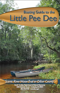
The Boating Guide to Little Pee Scenic River Water Trail in Dillon County (5mb PDF) provides a detailed description of river access and boating options (as well as natural and cultural history) for a 27-mile section of this scenic river from Moccasin Bluff Landing, just north of the City of Dillon, to Huggins Bridge Landing at SC Highway 41.
River access is available along the entire 48-miles of Little Pee Dee River in Dillon County. Four public boat ramps and other informal/unmanaged ramps and carry-in launch sites are dispersed along the river's length. Virtually all sections of the river accessed from these sites are navigable by small powerboats and canoes or kayaks; however, storm-downed trees and deadfalls may temporarily obstruct passage in some places.
Listed below are sites used by the public the access the Little Pee Dee River in Dillon County, and these sites are listed in order from upstream to downstream locations.
Informal access on the upper river – Upper reaches of the Little Pee Dee in Dillon County are accessed from public roads and bridges, and these are adjacent to private property. River users are urged to respect private property and restrict entrance to the river by using only the public right-of-way adjacent to the roads and bridges where allowed. Informal access sites at public roads include:
- State Road 363 (County Line Road) Bridge
- State Road 429 at McKays Bridge
- State Road 23 at Harlees Bridge
- Nortons Landing Road – This access site is at the end of Norton Landing Road off SC Highway 9 north of Dillon, on the south/west bank of the river. This site provides carry-in boat access. The boating distance from Nortons to the next landing at Moccasin Bluff is about 1.5 river miles.
Moccasin's Bluff Landing – This public landing is at the end of State Road 437 (Moccasin Bluff Road) on the north/east bank of the river. This site provides a paved boat ramp and parking. The Boating Guide to Little Pee Dee, as mentioned above (with link to PDF), begins its water-trail description of the river at this location and continues downstream. The boating distance downstream from this site to the next landing at Stafford Bridge is about 3.5 river miles.
Stafford Bridge Landing – This site is at the US Hwy 301/501 Bridge on the north/east bank of the river. A paved boat ramp with a dirt parking area is available at the site. Downstream distance from this site to the next landing at SC Hwy 9 at Dillon Bridge is about 4 river miles.
Dillon Bridge at SC Highway 9 – This site is at the old Hwy 9 Bridge which is immediately downstream, or south, of the active SC Hwy 9 Bridge. This site provides carry-in boat access to the river and parking on the old SC Hwy 9 roadbed which can be accessed from active SC Hwy 9 about 200 yards west of the bridge/river. Downstream distance from this site to the next landing at Dillon County Park is about 4 river miles.
Dillon County Park – This public landing is located off SC Hwy 57 at the end of River Access Road, south of the City of Dillon. The site provides a paved boat ramp and dirt parking area. Downstream distance from this site to the next landing at Floydale Bridge Landing is about 4.5 river miles.
Floydale Bridge Landing – This public landing is at the bridge crossing of Lester Road (State Road 45) on the north bank of the river. The site provides a paved boat ramp, parking area, and a picnic shelter. Downstream distance from this site to the next access area just above State Park Road is about 4 river miles.
Little Pee Dee State Park Bay Heritage Preserve - This area is on the north side of river just upstream of State Park Road (State Road 22) at Carmichael's Bridge. The site provides carry-in boat access to the Little Pee Dee River which is available at the end of a dirt road that turns west from State Road 22 about one-quarter mile north of the bridge crossing at the river. Little Pee Dee State Park is adjacent to and down-river from this site; the State Park borders approximately one mile of the river along the north bank. Downstream distance from this site to the next access area at Huggins Bridge (SC Hwy 41) is about 6 river miles.
Huggins Bridge Landing - This public landing is adjacent to the SC Hwy 41 Bridge and on the south/west bank of the Little Pee Dee River. The site provides a boat ramp, parking area, and picnic shelter. The Boating Guide to Little Pee Dee, as mentioned above (with link to PDF), concludes its water-trail description of the river at this location. Downstream distance from this site to the next access site at Allen's Bridge is about 6 river miles.
Allen's Bridge at Buck Swamp Road (State Road 72) - This site is limited to carry-in boat access within the road right-of-way at the bridge. Downstream from Allen's Bridge, the Little Pee Dee continues 1.25 miles to its confluence with Buck Swamp and the end of the designated scenic river. Another 7 rivers miles beyond Buck Swamp, the Little Pee Dee is joined by the Lumber River just south of Nichols, SC.