
Lynches Scenic River
The Lynches Scenic River designation extends approximately 111 river miles from US Highway 15 in Lee County to the confluence with the Great Pee Dee River in Florence County. The scenic designation occurred in two parts with the upper 57-mile section designated in 1994 and the lower 54-miles in 2008.
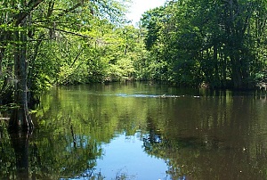
Along its winding course, the Lynches River passes through a varied landscape of pine uplands, farms, rural crossroads, and deep swamp forest. Special features include numerous small islands and sloughs, intermittent bluffs, bottomland hardwood wetlands, and artesian wells. The river corridor provides excellent habitat for fish and wildlife. Recreation opportunities include fishing, boating, wildlife observation, and camping. Sites for public access are well distributed along the river and these include Lee State Park and Lynches River County Park. Of particular historic interest is Snow's Island, an area of swampland formed in the convergence of Lynches River, Clark Creek and the Great Pee Dee River. Snow's Island is designated as a National Historic Landmark and listed in the National Register of Historic Places, because of its significance as a Revolutionary War campsite and retreat for General Francis Marion, the Swamp Fox, and his forces. In 2014, additional recognition was given to historic and recreational values of the Lynches River and Great Pee Dee River when a 66-mile section was designated The Revolutionary Rivers National Recreation Trail of South Carolina.
Partners for the Lynches Scenic River Project serve on an advisory council, which represents local landowners, river users, community interests, and SCDNR. Participation has included the SC Department of Parks Recreation and Tourism (SCDPRT), Lynches River Council, Lynches River Coalition/Clean Water, Lee County, Darlington County, Sumter County, Florence County, Pee Dee RC&D Council - US Natural Resources Conservation Service, SC Department of Health and Environmental Control, and River Rat Outfitters.
The Lynches River Advisory Council has developed the Lynches Scenic River Management Plan published in 1997 and revised in 2003. The plan identifies community goals and objectives for the river and recommends actions to address issues of river stewardship and community involvement, water quality, fisheries, wildlife and habitat management, aesthetic/scenic values, and recreational use. The 2008 Lynches River Eligibility Study reports findings and recommendations for Scenic River designation of the lower 54-miles of the Lynches River.
Recreational Access
The Lynches Scenic River Water Trail Guide was produced in 2009 to assist the public with accessing and traveling the river by boat to promote appreciation, conservation and protection of the river's resources.
Landings and access sites on Lynches Scenic River are listed below from upstream to downstream locations. The corresponding river miles are numbered in the opposite direction and measure distance upstream from the river's end, at the Great Pee Dee.
| Landings, access sites on Lynches Scenic River | River Mile |
|---|---|
| US Highway 15 Landing near Bishopville | 111 |
| Lee State Park, carry-in boat access sites | 106-105 |
| US Highway 401 Landing near Elliott | 96 |
| US Highway 76 Landing near Lynchburg | 86 |
| US Highway 301, carry-in boat access | 67 |
| State Road 55 (McAllister Mill or Meadow Prong Road), carry-in boat access | 50 |
| Lynches River County Park, canoe launch site | 55 |
| US Highway 52 Landing near Effingham | 50 |
| Jeffords Road Landing, northeast of Coward | 47 |
| Landing below State Road 46 Bridge on Farrell Drive | 43 |
| Indigo Landing at end of Indigo Landing Road | 39 |
| Landing above US Highway 378 at Wicklow Road | 34 |
| Riverside Cemetery Road Landing | 30 |
| Sandstone Road Landing | 25 |
| Half Moon Road Landing (State Road 49) | 20 |
| SC Highway 41/51, Venters Landing near Johnsonville | 8 |
| Eaddy Landing at Eaddy Landing Road | 5 |
| Persimmon Bluff Landing at N Persimmon Bluff Road | 4 |
| Rivers end - Lynches River enters Great Pee Dee | 0 |
Downstream boating options - From Persimmon Bluff Landing on Lynches Scenic River, boaters have choices for destinations downstream on the Great Pee Dee or at Snow Lake. Use of map and compass or GPS is recommended for navigating stream channels to the following sites:
- Staple Lake Landing on the Great Pee Dee River – This landing is about 12 river miles downstream. It can be reached by navigating about 3 miles on the Lynches River to where the main channel becomes Clark Creek (and Lynches River forks to the left), then travel Clark Creek for 7.5 miles to the Great Pee Dee River, and finally 1.5 miles down the Great Pee Dee to Staple Lake on the west/south bank.
- Dunham Bluff Landing on the Great Pee Dee River – This site is about 6 miles downstream and may be reached by navigating about 3 miles on the Lynches River to where the main channel becomes Clark Creek and Lynches River forks left. Follow the Lynches River channel eastward for about 1 mile to its confluence with the Great Pee Dee (in this section log jams may block passage), then follow the Great Pee Dee about 2 miles downstream to Dunham Bluff on the north bank.
- Snow Lake Landing – This site is about 5 river miles downstream. It is reached by navigating 2 miles on Lynches River, then 2 miles on Mill Creek, and finally, 1 mile on Muddy Creek to Snow Lake. From Snow Lake, boaters may continue east on Muddy Creek to Clark Creek to reach the Great Pee Dee River.