
Catawba Scenic River
Project Overview
The 30-mile section of the Catawba River in York, Lancaster and Chester counties, extending from Lake Wylie dam downstream to the SC Highway 9 Bridge was designated a State Scenic River in June 2008. The Catawba is a large dam-regulated Piedmont river which provides outstanding scenery, recreational fishing and boating opportunities, and other nature-based recreations.
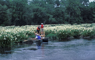
The Catawba River corridor and adjacent uplands contain large acreages of undeveloped forestland, with a mix of agricultural and pasture lands. Natural communities with high resource value include the wet, rocky shoal areas in the river channel and the forested habitats of the river floodplain and its bluffs. This section of the Catawba is best known for its large stand of rocky shoals spider lily (Hymenocallis coronaria) which has a spectacular bloom in mid-May to mid-June each year and may be viewed by boat or along the shores of Landsford Canal State Park.
Partners for the Catawba Scenic River Project serve on an advisory council, which represents local landowners, river users, community interests, and SCDNR. Participation has included Katawba Valley Land Trust, Duke Energy, SCPRT (Department of Parks, Recreation and Tourism) Catawba Regional Council of Governments, Nation Ford Land Trust, Catawba Indian Nation, Catawba Riverkeeper Foundation, Rock Hill Utilities, AbitibiBowater, Sierra Club, Newland Communities, and York County.
Additional information about the Catawba and its scenic river designation is available in the Catawba River Eligibility Study published in 2008. (PDF).
Prior to scenic river designation, the Catawba River in South Carolina was the subject of study and management considerations by a task force which represented river stakeholders and produced the Catawba River Corridor Plan published in September 1994.
Public Access
The Catawba Scenic River may be explored and enjoyed from several public access sites and parks, which are listed below in order from upstream to downstream locations.
Fort Mill Access - This public landing provides a boat ramp and parking area. The site is located just downstream of Lake Wylie dam off New Gray Rock Road (State Road 251) west of Fort Mill in York County. Boating distance from this site to the next access location at Rock Hill River Park is about 7 river miles.
Piedmont Medical Center Trail – This walking and biking trail in Rock Hill offers views of the Catawba River. At its north end, this trail connects to Cherry Road (US Highway 21) and on the south end it connects to trails at Rock Hill River Park.
Rock Hill River Park - This park provides walking trails along the river, picnic areas, and a carry-in boat launch (with nearby parking) located at the mouth of Manchester Creek on the Catawba River. River Park landing is at the end of Quality Circle (a road) which is off Red River Road (State Road 50) in Rock Hill. Boating distance from this site to the next access location at Landsford Canal State Park is about 17 river miles.
Landsford Canal State Park – The state park provides walking trails along the river, historic canal structures, picnic areas, parking, and carry-in boat access. Two carry-in boat access sites at the park (one upstream, and the other downstream) provide a 1.6 mile paddling trip through the large stand of rocky shoals spider lilies of the Catawba River. Lansford Canal State Park is on Landsford Road (State Road 327) in Chester County. Park hours are 9AM to 6PM daily, admission fees are charged. Boating distance from this park to the next access location at Highway 9 Landing is roughly 6 river miles.
Highway 9 Landing - This site provides a public boat ramp with parking, and is located adjacent to the SC Highway 9 Bridge in Lancaster County.
Additional information for exploring the Catawba River and points of interest along the way is provided by Duke Energy at the website - Catawba River Canoe Trail Map.
Safety Considerations
Activities on the Catawba River such as boating, wade fishing, and swimming can become dangerous at certain water levels and in certain areas. River levels are affected by rain events and water releases from Lake Wylie dam. Higher water levels can cause shoals in the river to become class II or III rapids (particularly at Sugar Creek and Landsford shoals), which require more skill to navigate. At Lake Wylie dam there is a warning system in place to alert boaters and wading anglers of releases and rising water conditions, however, the release sirens can only be heard near the dam. River users should always remain alert to changing river conditions and possible safety hazards in the river, and be prepared for safety.