
Little Pee Dee Scenic River
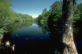
The Little Pee Dee River from US Highway 378 Bridge to its confluence with the Great Pee Dee River (about 14 river miles) was designated a State Scenic River in 1990. The Little Pee Dee, which flows between Horry and Marion counties is an outstanding example of a Coastal Plain blackwater river in South Carolina. Tea-colored water, cypress-tupelo swamps, lakes, and sandy stream bottoms and bars characterize this river section.
The Little Pee Dee is a popular recreation destination for boating and fishing. Freshwater fishes sought by anglers include bluegill, redbreast, largemouth bass, crappie, and catfish. Recreational boating, in canoes and small power boats, is popular year round.
Other sections of the Little Pee Dee River system have been considered for State Scenic River designation. Immediately upstream of US Highway 378, an additional 64-mile section of the Little Pee Dee River was determined eligible for scenic river status in 1997 but was never officially designated (see the 1998 final report, Little Pee Dee - Lumber River Eligibility Study (PDF link)). Further upstream, the Little Pee Dee Scenic River in Dillon County (a 48-mile section) was designated in 2005. In addition, there is the Great Pee Dee Scenic River, designated in 2002, which adjoins the lower Little Pee Dee and extends 70-miles from US Highway 378 to US Highway 17 at Winyah Bay.
Partners for South Carolina Scenic River Projects serve on local advisory councils that represent local landowners, river users, community interests, and South Carolina DNR. The Little Pee Dee and the adjoining Great Pee Dee are two State Scenic Rivers which the DNR has merged into one Project with one advisory council. The combined advisory council, called the Pee Dee Scenic River Advisory Council, includes members representing both scenic rivers. Participation has included resident property owners, Georgetown County Historical Society, SC Coastal Conservation League, Red Mountain Timber Company, Georgetown County, Horry County, Pee Dee River Watchers, Wildlife Action, Winyah Rivers Foundation, The Nature Conservancy, US Fish and Wildlife Service, Baruch Institute, Coastal Carolina University, and SCDHEC.
Recreational Access / Boat Landings
A number of public access areas are available to support public use and enjoyment of the Little Pee Dee Scenic River. Access areas are listed below in order from upstream to downstream locations. Boating Guide to the Little Pee Dee - file size 5MPitts Landing - At the US Hwy 378 crossing there are two boat landings, one on either side of the river. On the west side, in Marion County just upstream of the bridge is the unmanaged Potato Bed Ferry Landing. In Horry County, on the east bank of the river is Pitts Landing, which is located about 600 yards downstream of the bridge. Pitts Landing provides a boat ramp and parking area, and is accessed from US Hwy 378.
Upstream of US Hwy 378 and adjacent to the Little Pee Dee River is a series of state-owned properties which comprise the 9,000-acre Little Pee Dee River Heritage Preserve Wildlife Management Area.
Sampson Landing – Note, this site is not located on the main channel of the river. It's on an oxbow lake (Sampson Lake) which from its north end connects to the main channel of the Little Pee Dee at about four river-miles downstream from US Hwy 378. Sampson Lake and the landing are at the west side of the Little Pee Dee River swamp in Marion County and within the Woodbury Wildlife Management Area and Heritage Preserve. Distance from the river to the landing via Sampson Lake is about one-half mile. This landing provides a boat ramp and parking area, and the site is located at the end of Sampson Landing Road which is an east turn from Woodbury Road.
Woodbury Wildlife Management Area and Heritage Preserve – This area consists of 25,668 acres managed for wildlife and recreation and is located at the south end of Marion County between the Little Pee Dee and Great Pee Dee Scenic Rivers. Entrances to Woodbury WMA/HP are located off US Hwy 378 on Woodbury Road or Pet Larrimore Road, and are marked with brown reflective signs. Hunting, fishing, boating, birding, hiking, biking, and wildlife viewing are among the more popular activities enjoyed by visitors. Boat ramps within this property are located at Dunham Bluff and Tan Yard landings which access the Great Pee Dee River, and at Sampson, Sanders and Parker landings which access tributaries and side channels to the Little Pee Dee River.
Punch Bowl Landing – This site located on the east bank of the river in Horry County at the end of Punch Bowl Road about 8 river-miles downstream from US Hwy 378. The landing provides a boat ramp, courtesy dock and parking area, and the area is a popular destination for sunning, swimming, and wading in the river. The distance downstream from Punch Bowl Landing to Little Pee Dee confluence with the Great Pee Dee River is about 5 river miles.
Sanders and Parker Landings - These two sites are located on Russ Creek, which is a side-channel of the Little Pee Dee River swamp in Marion County. The landings and Russ Creek are all within the Woodbury Wildlife Management Area and Heritage Preserve. Sanders and Parker landings are 0.75 miles apart, both are accessed from Woodbury Road, and they provide boat ramps and parking areas. Russ Creek, at its upstream/north end, connects with the Little Pee Dee River channel about 2-miles (swamp-creek miles) above Sanders Landing. Downstream, Russ Creek extends roughly 1-mile eastward from Parker Landing to a divided channel and presents optional routes: (1) head north/east for a quarter mile and enter the Little Pee Dee River channel, or (2) turn south, remain in the western channel (which is Russ Creek to Russ Lake) and ultimately join the Little Pee Dee channel. By either route, the distance from Parker Landing going downriver to the Little Pee Dee confluence with the Great Pee Dee River is about 3.5 river miles.
The following two landings are located on the Great Pee Dee and can be useful to boating on the Little Pee Dee.
Tan Yard Landing – Located on the Great Pee Dee River, Tan Yard Landing is just upstream, only three-quarters of a mile from where the Little Pee Dee joins the Great Pee Dee. This site is at the end of Woodbury Road in Marion County within the Woodbury Wildlife Management Area and Heritage Preserve. This landing provides a dirt ramp and parking area.
Yauhannah Landing – On the Great Pee Dee River at the base of the US Hwy 701 Bridge in Horry County, this facility provides a ramp, courtesy dock, and parking area. It's located about 5 river-miles downstream of where the Little Pee Dee enters the Great Pee Dee River.