 2 Pulses of Hot Water Hit South American Coast in June
 Rebounding Along the Surface Someplace South of Hawaii
 Stimulated by Removal of Wind Pressure From the Indonesian Area
| El Nino/Southern Oscillation | ||
|---|---|---|
| Section | Section | Section |
| Description | Impacts | Outlook |
 Collapse or Relaxation of Normal Persistent East-to-West Equatorial Tradewinds in Pacific
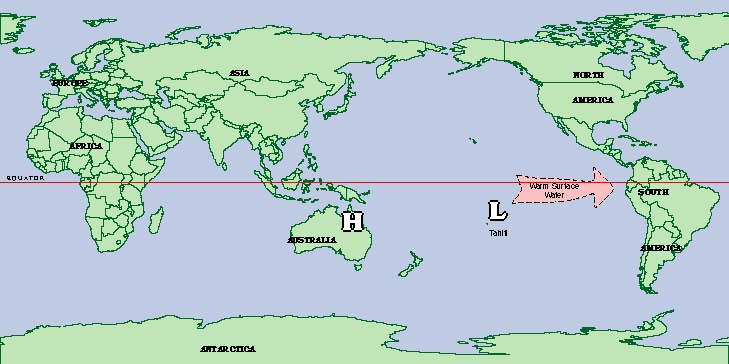
 Migration Westward of Large Atmospheric High Pressure Cell Over South Pacific From Tahiti to Australia
 Large Mass of Water Migrates Eastward Across Pacific Ocean from Formation Area Around Indonesian & Philippine Archipelagoes
 2 Pulses of Hot Water Hit South American Coast in June
 Rebounding Along the Surface Someplace South of Hawaii
 Stimulated by Removal of Wind Pressure From the Indonesian Area

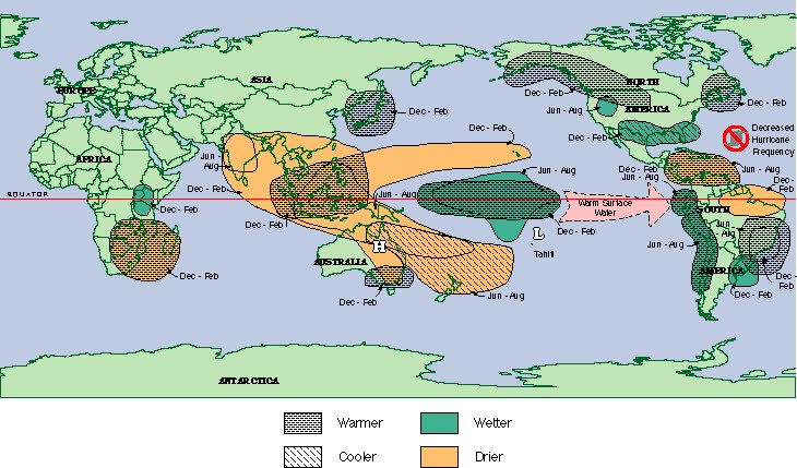
 Intense droughts in Australa, India, Indonesia, Philippines, Brazil, parts Africa, the Western Pacific Basin Islands, Central America
 Milder winters in the Northeast
 Wet over the south from Florida to Texas
 Alaska and NW regions of Canada and US can be abnormally warm
 Hurricane activity minimal in Atlantic Ocean
 Rain and flooding to California, Oregon and Washington

 When Large Mass of Hot Water Came to Americas
 Atmosphere Reacted by Trying to Move Heat Out in 2 ways
 Indirect Product of Two Changes in the Atmosphere

During an El Nino Event, South Carolina can expect the following:
 Summer Rapidly Disappearing From Memories & Thermometer
 Another Part of El Nino Process Starting Up
 Start as Moist, Warm, Tropical Jetstream
 SC Can Expect Between 120 - 135% Normal Precipitation within 6 - 10 months of the onset of a typical El Nino event
 Reserch on Historical Records Show 2 Worrisome Trends