
Southeast Coast Saltwater Paddling Trail
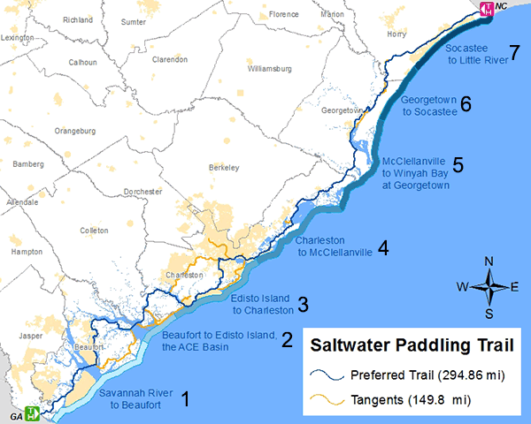
![]() The South Carolina section of the Southeast Coast Saltwater Paddling Trail extends 295 miles from the Savannah River at the Georgia border through the Carolina Sea Islands, past the port of Charleston, along the Grand Strand, and ends at Little River on the North Carolina border. This section offers a paddling trail with a diversity of natural and cultural features, and includes every South Carolina coastal habitat type, from tidal waters, marshlands, and swamps to barrier islands, dunes, and beaches. Many cultural sites and places of interest are accessible by kayak including old forts, plantations, fishing villages, port cities, resorts, and many protected wildlife areas.
The South Carolina section of the Southeast Coast Saltwater Paddling Trail extends 295 miles from the Savannah River at the Georgia border through the Carolina Sea Islands, past the port of Charleston, along the Grand Strand, and ends at Little River on the North Carolina border. This section offers a paddling trail with a diversity of natural and cultural features, and includes every South Carolina coastal habitat type, from tidal waters, marshlands, and swamps to barrier islands, dunes, and beaches. Many cultural sites and places of interest are accessible by kayak including old forts, plantations, fishing villages, port cities, resorts, and many protected wildlife areas.

| Map No. | From Location | To Location | Waterway(s) Primary Paddling Trail | Approximate Distance |
|---|---|---|---|---|
| 1 | Savannah River, Georgia Border | Beaufort | Savannah River, Cooper River, Mackays Creek, Port Royal Sound, Beaufort River, Coosaw River | 60 |
| 2 | Beaufort | Edisto Island, the ACE Basin | Morgan River, St. Helena Sound, Ashepoo River, South Edisto River, Dawho River | 30 |
| 3 | Edisto Island | Charleston | North Edisto River, Wadmalaw River, Stono River, Elliot Cut, Wappoo Cut, Charleston Harbor | 50 |
| 4 | Charleston | McClellanville | Charleston Harbor, Intracoastal Waterway, Bulls Bay | 50 |
| 5 | McClellanville | Winyah Bay at Georgetown | South Santee River, Intracoastal Waterway, North Santee River, Esterville Minim Creek Canal, Winyah Bay | 40 |
| 6 | Georgetown | Socastee, lower Pee Dee and Waccamaw | Great Pee Dee River, Waccamaw River, Intracoastal Waterway | 30 |
| 7 | Socastee | Little River, Intracoastal Waterway at North Carolina Border | Little River, Intracoastal Waterway | 35 |
Approximate Total Distance in Miles |
295 |
|||
Related Websites
- ACE Basin National Estuarine Research Reserve
- Discover the ACE Basin
- Paddle SC
- South Carolina Department of Natural Resources
- South Carolina State Parks
- South Carolina State Trails Program
- South Carolina Official Tourism Site
- Charleston County Park and Recreation Commission
- Waccamaw River Blue Trail